THE CASTLE OF ROSUJA IN TROPOJA AND THE ARCHAEOLOGICAL SEGMENT UP TO ULPIANA
Findings, Comparisons, and the Historical–Archaeological Development of the Dardanian Space
Flamur Buçpapaj
Archaeological Study for Students of History and Archaeology
Historical and Archaeological Context
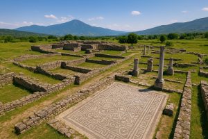
Ulpiana, known in Roman sources as Municipium Ulpiana Splendidissima, is located about 12 kilometers southeast of Prishtina, near the village of Gadime e Epërme in the municipality of Gračanica. Founded during the reign of Emperor Trajan (98–117 AD), the city represents one of the earliest centers of Roman urbanization in Dardania. Over time, it developed into an important economic, military, and cultural hub connected by ancient roads to the cities of Naissus (Niš), Scupi (Skopje), and Lissus (Lezhë).
After the great earthquake of 518 AD, Ulpiana was almost completely destroyed. However, thanks to the intervention of Emperor Justinian I, it was rebuilt and renamed Iustiniana Secunda. This symbolic transformation demonstrates the importance Justinian attributed to the province of Dardania, both as his place of origin and as a strategic center for the defense of the empire’s borders.
Introduction to the Archaeological Segment Tropoja – Ulpiana
The area stretching from Rosuja in Tropoja to Ulpiana in Kosovo constitutes a unique archaeological segment, closely linked to the history of ancient Dardania and the later development of the Roman provinces of Northern Illyria. This segment includes a network of fortresses, settlements, trade routes, and clerical centers that testify to the continuous development of human life from the Illyrian to the Byzantine era.
Along this historical route, the Castle of Rosuja represents a northern strategic defense point, while Ulpiana served as the southeastern political, administrative, and urban center of the same Dardanian cultural universe. Both sites demonstrate a high level of social and technical organization, as well as adaptation to historical transformations brought about by imperial conquests and influences.
The Castle of Rosuja in Tropoja – Archaeological Findings and Significance
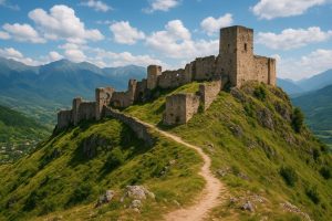
The Castle of Rosuja, located on the mountain above the village of Rosuja, about 4 kilometers northeast of the city of Bajram Curri, is one of the oldest monuments of the Albanian Alps region.
According to archaeological evidence found on site and the research of local scholars, the fortification dates back to the Late Iron Age and the Illyrian–Roman period (4th century BC – 2nd century AD).
Partial excavations have revealed:
Defensive walls built with large cyclopean stones, typical of Illyrian fortifications;
Ceramic objects from the early Roman period, indicating contact with the southern zones of Dardania;
Secondary settlements surrounding the fortress, suggesting stable habitation;
Pagan cult objects and ritual elements related to Illyrian mountain and nature worship.
Its role was strategic — serving as an observation and defense point for the Valbona Valley and the route connecting it with the White Drin Valley, and therefore with the Dardanian communication network stretching toward present-day Kosovo and beyond, up to Ulpiana.
The Archaeological Link Segment Rosuja – Ulpiana
The route connecting Tropoja to Kosovo through the mountain passes of Çerem, Gjakova, Deçan, and Llapi corresponds to the ancient Dardanian road, which in the Roman period was transformed into a trade and military route (via militaris).
Along this line, several archaeological sites have been identified:
Kastrati of Gashi and Vuthaj – pre-Illyrian fortifications with material culture elements similar to those of Rosuja;
Deçan and Junik – settlements with traces from the Roman period, including amphorae, ceramics, and construction remains;
Theranda (Suhareka) and Vendenis – major Dardanian centers evidencing the urban network that preceded Ulpiana.
This cultural and archaeological segment demonstrates a continuous civilization pattern, where Ulpiana’s influence as a southern urban and administrative center extended northward, spreading the Roman model of organization toward Tropoja and the alpine regions of northern Dardania.
Ulpiana – The Urban Center of the Roman Dardanians
Municipium Ulpiana Splendidissima was founded in the 2nd century AD under Emperor Trajan, on top of an earlier Dardanian settlement. During the Roman period, it became a flourishing urban center, characterized by monumental architecture, administrative buildings, public baths, temples, and necropolises — representing the height of Roman civilization in the Dardanian provinces. In the Roman period, Ulpiana became:
an urban center with forums, thermae (public baths), paved roads, and religious buildings;
a prosperous economic hub, thanks to its mineral resources and its location along major trade routes;
an important clerical center after its conversion in the Late Roman period, marked by the construction of paleo-Christian basilicas and Justinian-era mosaics.
After the earthquake of 518 AD, Emperor Justinian I rebuilt the city, renaming it Iustiniana Secunda in honor of his Dardanian origin and to make it a new ecclesiastical and administrative center of the province.
Compared to Rosuja, Ulpiana represents the urban phase of Dardanian cultural and state development, while Rosuja represents the Illyrian defensive and pre-urban foundation of that evolution.
Archaeological Comparison Rosuja – Ulpiana
Element Castle of Rosuja Ulpiana
Chronology Illyrian – Early Roman (4th c. BC – 2nd c. AD) Roman – Byzantine (2nd – 6th c. AD)
Function Defensive fortification, local center Urban, administrative, and ecclesiastical center
Typical findings Coarse Illyrian pottery, iron weapons, cyclopean stones Mosaics, amphorae, coins, basilicas, inscriptions
Material culture Indigenous Illyrian with partial Roman influence Developed Roman culture with Byzantine elements
Location Mountainous, strategic for defense Lowland plain, crossroads of trade routes
Symbolic role Defense and local identity Civilization, development, and imperial connection
This comparison illustrates the evolution of Dardanian society from the mountain-based culture toward urban civilization — a process that encapsulates the transition from Illyrian fortresses to Roman cities.
Historical–Cultural Interpretation
The route extending from Rosuja to Ulpiana represents the historical axis of Dardanian development.
Along this axis emerged:
the core of Illyrian–Dardanian cultural identity, which later became the substratum of broader Balkan civilization;
the transition from tribal structures to state organization, influenced by Roman administration;
the development of infrastructure and the local economy, culminating in urban centers such as Ulpiana, Theranda, and Naissus.
Rosuja, as an Illyrian-era archaeological site, stands as evidence of Dardanian autochthony, while Ulpiana, as a Romanized center, represents the assimilation of the imperial model without losing connection to its native ethnic base.
Rosuja symbolizes the beginning of Dardanian civilization in its defensive and traditional form.
Ulpiana embodies the culmination of urbanization and Romanization in this region.
The Rosuja–Ulpiana segment is a golden line of cultural and technical development in Dardania, connecting the Illyrians with the Roman and Byzantine worlds.
The comparative study of these two sites helps to reconstruct a new historical map of the evolution of Albanian civilization — from the Illyrian fortification of Rosuja to the monumental Roman city of Ulpiana.
The Tropoja region, located in northern Albania, constitutes one of the richest areas in archaeological findings that testify to the close connection between Illyrian and Roman cultures.
Within this historical mosaic, the Castle of Rosuja stands out as a fortified center strategically positioned on a hill overlooking the Valbona Valley, controlling the natural routes that linked Dardania with the Adriatic coast.
The archaeological discoveries and the structural characteristics of the site demonstrate steady urban and military development from the Late Illyrian period to the early centuries after Christ.
This settlement forms a key link in the communication network connecting major centers such as Lissus (Lezhë), Scodra (Shkodër), and northeastward toward Ulpiana (Gračanica, Kosovo).
Strategic Position and Historical Importance
The Castle of Rosuja is situated on elevated hilly terrain (around 900 meters above sea level), providing a broad view over the Valbona Valley and the natural route that passes through the Morina Pass toward Kosovo.
From this position, it controlled the movement of trade and military caravans, which were connected to the ancient Dardanian roads that led to Ulpiana, one of the most important economic and administrative centers of the Illyrian–Roman province.
Its location indicates that Rosuja was a nodal point in the Illyrian–Dardanian itinerary — a segment that served as a bridge between the culture of the Illyrian Alps and the Roman civilization of the Balkan interior.
Archaeological Findings in the Castle of Rosuja
Early local archaeological expeditions have revealed:
Cyclopean perimeter walls, built with large uncemented stones, typical of Illyrian fortifications;
Handmade and wheel-thrown ceramics, dated to the Late Iron Age;
Roman coins from the 1st–3rd centuries AD, evidencing trade contacts with the Empire;
Bronze and iron artifacts (fibulae, spearheads, knives, ornaments);
Architectural foundations, possibly part of a residential or military complex.
According to comparative analyses, the construction techniques of the fortification walls correspond to those discovered in the Upper Dalmatian fortresses, Gajtan, and the Dardanian centers of Artana and Ulpiana, confirming a shared Illyrian–Dardanian building culture.
The Archaeological Segment Rosuja–Ulpiana
From a topographical and historical perspective, the segment connecting Rosuja to Ulpiana represents an ancient communication route that likely followed the later Roman road crossing the Albanian Alps and Dardania. This road passed through Valbona, the Morina Pass, Gjakova (ancient Little Doclea), and ended in Ulpiana, following a southwest–northeast direction.
Along this segment, archaeologists have discovered:
Architectural remains and worked stones using ancient techniques in the Curraj area and in the old ruins of Gjakova;
Tumulus cemeteries along the stretch between Tropoja and Junik;
Metal and ceramic objects that testify to a cultural and commercial circulation between the two regions.
These findings imply that between Rosuja and Ulpiana there existed a living cultural and economic axis that was later integrated into the Roman road system after the conquest of Dardania.
Archaeological Comparison between Rosuja and Ulpiana
Element Castle of Rosuja Ulpiana
Architectural typology Hilltop fortification with cyclopean walls (Illyrian type) Planned Roman city with an orthogonal street network
Period of prosperity 4th century BC – 3rd century AD 2nd – 6th centuries AD
Function Military and trade control Administrative, economic, and religious center
Characteristic findings Illyrian pottery, iron weapons, bronze fibulae Mosaics, basilicas, Latin inscriptions
Cultural influences Indigenous Illyrian and Dardanian Roman and Byzantine
Regional role Connecting point between the Albanian Alps and Dardania Metropolitan center of the province of Dardania
This comparison shows that while Ulpiana represents the culmination of Roman urbanization in Dardania, Rosuja represents the earlier phase of this process — a proto-urban Illyrian nucleus that was gradually integrated into the imperial cultural and political system.
Cultural Development and Influence on Archaeological Heritage
The findings at Rosuja and the roads linking it with Ulpiana are evidence of cultural interaction between Illyrians and Romans, resulting in the formation of a hybrid Illyro–Roman identity.
In this respect, Rosuja represents the transition from Illyrian fortresses to Roman-type cities.
Today, its remains constitute a largely unexplored archaeological heritage, with great potential for archaeological study and cultural tourism development.
Research Proposals
The Castle of Rosuja should be considered an integral part of the Illyrian–Dardanian archaeological itinerary that culminates in Ulpiana.
A joint Albanian–Kosovar archaeological project should be undertaken to trace the ancient Rosuja–Ulpiana route.
The findings in Rosuja could help reconstruct the early stages of urbanization in Dardania.
The area holds potential for a local archaeological museum and a historical interpretation center, which could promote cultural tourism in Tropoja.
Conceptual Illustrations and Map of the Rosuja–Ulpiana Segment
To better understand the historical route and archaeological segment, a conceptual map is proposed:
Position of Rosuja Castle: mountain above the village of Rosuja, overlooking and controlling the Valbona Valley.
Tropoja–Ulpiana road segment: crosses the Morina Pass, Gjakova, Deçan, and reaches Ulpiana.
Settlements and auxiliary fortifications: Kastrati i Gashit, Vuthaj, Deçan, Junik, Theranda (Suhareka).
Roman strategic points: road intersections, bridges, amphora sites, and secondary settlements.
Visualization Ideas
Map showing ancient routes, locations of fortresses, and Roman cities;
Sketches of Rosuja’s cyclopean walls and the urban plan of Ulpiana;
Comparative diagram of ceramic and metal objects from Rosuja and Ulpiana;
Historical evolution map: Illyrians → Romans → Byzantines.
The Castle of Rosuja and the Tropoja–Ulpiana segment represent the historical line of urbanization and defense in Dardania.
The comparison between these two sites illustrates the transition from Illyrian defensive structures to Roman and Byzantine cities.
Preserving and studying this segment will enrich knowledge about the history, architecture, and material culture of the region.
Integrated archaeological and tourism projects are recommended to promote heritage and support local economic development.
CHAPTER III – URBAN, RELIGIOUS, AND ECONOMIC DEVELOPMENT IN ULPIANA AND COMPARISON WITH THE NORTHERN SEGMENT (ROSUJA, DEÇAN, GJAKOVA)
Ulpiana, also known as Iustiniana Secunda after its reconstruction by Justinian I (6th century AD), represents the peak of urban and cultural development of Dardania during the Roman and Byzantine periods.
Meanwhile, the northern sites such as Rosuja Castle, Deçan, and Gjakova represent the proto-urban and defensive phase, preserving early Illyrian and Roman elements.
Their comparison helps understand:
the transition from mountainous fortifications to urban-planned cities;
the development of the economic and trade network;
the spread of early cults and clerical institutions.
Urban Development in Ulpiana
Planning and Infrastructure
Ulpiana was built on an orthogonal plan, typical of Roman urbanism, featuring:
The Forum as an administrative and commercial center;
Public thermae, built according to the Roman model for hygiene and leisure;
Paved streets connecting the forum, basilicas, and city gates;
An advanced drainage and water reservoir system for the Dardanian region.
Recent excavations have revealed Latin inscriptions, coins, and ceramic objects, indicating intensive economic and urban activity between the 2nd and 6th centuries AD.
Clerical and Religious Complexes
Ulpiana is distinguished for its paleo-Christian basilicas and mosaics with geometric and figurative motifs, demonstrating a city with an active religious life.
Its reconstruction by Justinian I emphasizes its importance as an ecclesiastical center of the province of Dardania.
Compared to Rosuja, where religious traces are linked to Illyrian mountain cults, Ulpiana represents the formalization of Christian worship and Byzantine influence.
Economic Development
Ulpiana: a city with organized markets, ceramic and metal production, and trade with surrounding regions;
Rosuja and Deçan: bases for rural supply and strategic fortifications; the economy was mainly agricultural and military (weapon-making);
Coins and amphorae indicate a trade network connecting Montenegro, Kosovo, and Dardania;
The Rosuja–Ulpiana routes facilitated the movement of goods, armies, and people.
Comparison with the Northern Segment
Element Castle of Rosuja Deçan Gjakova Ulpiana
Main function Defensive Residential & fortified Residential & light trade Urban, administrative, religious center
Material culture Illyrian and early Roman pottery Roman-period pottery Coins, trade artifacts Mosaics, basilicas, Latin inscriptions, trade objects
Position Mountainous, strategic Valley, near water sources Valley, trade routes Plain, crossroads, urban hub
Historical role Local control, defense Processing and supply Local trade node Metropolitan and commercial center, regional influence ChatGPT-ja tha:
This comparison illustrates the hierarchical system of urban and economic development:
Rosuja as a strategic base, Deçan and Gjakova as intermediary settlements, and Ulpiana as the main urban and religious center.
Cultural and Social Impact
Ulpiana served as a model of Roman civilization in Dardania, encompassing urban planning, religious cults, and a developed economic network.
Rosuja and the northern segment preserved the Illyrian–Dardanian substratum, providing evidence of the region’s indigenous identity.
The influence of urban networks and trade routes contributed to the integration of the region into the Roman Empire and later into the Byzantine realm.
Ideas for Development and Conservation
Integrated archaeological projects connecting Rosuja, Deçan, Gjakova, and Ulpiana to document the urban and road network;
GIS mapping of archaeological sites and historical routes for visualization and academic study;
Museums and interpretation centers at each nodal point of the segment to promote archaeological tourism;
Conservation of basilicas, mosaics, and masonry structures to ensure the preservation of heritage.
Urban development in Ulpiana represents the apex of Roman and Byzantine civilization in Dardania;
The northern segment (Rosuja, Deçan, Gjakova) preserves the proto-urban and defensive phase, reflecting early Illyrian life;
The comparison shows the transition from mountainous fortifications to urban settlements, and from indigenous culture to Roman and Byzantine influences;
The study integrates urban, religious, and economic development, creating a comprehensive historical–archaeological panorama of the region.
CHAPTER IV – TRADE AND MILITARY NETWORKS, JUSTINIAN’S RECONSTRUCTION, AND HERITAGE CONTINUITY IN THE ROSUJA–ULPIANA AXIS
The segment connecting the Castle of Rosuja with Ulpiana was not only a line of habitation but also a strategic and commercial corridor, linking the northern parts of Dardania with its southeastern urban centers.
The networks along this route shaped the urban, economic, and military development of the region, creating a strong connection among:
Illyrian bases (Rosuja)
Intermediate settlements (Deçan, Gjakova)
Urban and administrative center (Ulpiana / Iustiniana Secunda)
The reconstruction of Ulpiana by Emperor Justinian I strengthened the importance of this route, turning it into an economic, military, and ecclesiastical hub of Byzantine Dardania.
Trade Networks and Economic Movement
Trade Routes:
From Valbona–Rosuja–Morina Pass–Deçan–Gjakova–Ulpiana, this corridor facilitated the transport of grain, livestock, minerals, and ceramics.
Ulpiana had regular markets and storage facilities for amphorae, agricultural tools, and metals.
Commercial Nodes:
Rosuja: basic supply point and checkpoint;
Deçan and Gjakova: local markets and storage depots;
Ulpiana: urban markets, export center, and tax administration.
Connection to the Regional Network:
Through this route, goods from Montenegro, western Albania, and Dardania reached Ulpiana, and from there extended toward Naissus (modern Niš) and other regional centers.
The trade comparison indicates a hierarchical structure: Rosuja as the starting point, intermediary settlements as logistical centers, and Ulpiana as the main economic hub.
Military Networks and Defensive Strategy
Castle of Rosuja: observation and defense point of the northern axis, controlling movement through the Albanian Alps;
Intermediate settlements (Deçan, Gjakova): small garrison forces and shelter bases for trade caravans;
Ulpiana: urban fortifications with wide walls and fortified gates, especially after Justinian’s reconstruction.
Comparative Analysis:
Rosuja: local, proto-military defense;
Ulpiana: strategic defense of the city and main roads;
The entire segment: formed an integrated defense network that ensured transport and trade security across the region.
Justinian I’s Reconstruction and Byzantine Influence
After the earthquake of 518 AD, Ulpiana was partially destroyed, necessitating reconstruction by Emperor Justinian I.
The main changes included:
Urban Reconstruction:
Restoration of the main streets and city gates;
Reinforcement of walls and defensive towers;
Reconstruction of the forum and public thermae.
Clerical and Cultural Structures:
Construction of new basilicas with mosaics and altars;
Transformation of the city into a Byzantine administrative and ecclesiastical center.
Economic Network and Taxation:
Stabilization of regional trade;
Management of taxes on goods passing through the northern–northeastern corridor;
Stronger integration with the Byzantine Empire.
This reconstruction marks the second developmental phase of Ulpiana, transforming it from a local center into a regional strategic and cultural hub.
Modern Projects for Heritage Preservation
Mapping and GIS: creation of a digital map of the Rosuja–Ulpiana network for visualization and archaeological research;
Museums and Interpretation Centers: exhibitions of findings from Rosuja, Deçan, Gjakova, and Ulpiana;
Restoration of masonry and mosaics to prevent degradation and promote heritage;
Archaeological and educational tourism: establishment of a historical route Tropoja–Ulpiana with information panels, guided visits, and cultural activities;
International cooperation projects: involving researchers from Albania, Kosovo, and Central European universities for excavations and publications.
The Rosuja–Ulpiana network was an economic, military, and cultural axis linking the Albanian Alps with the urban centers of Dardania.
Justinian’s reconstruction reinforced Ulpiana’s importance as a regional hub.
The preservation and study of this segment offer opportunities for scientific, educational, and touristic integration, promoting both cultural and historical heritage. Modern Projects and GIS Mapping Can Create a Model for the Management of Archaeological Heritage in the Balkans
CHAPTER V – COMPARATIVE ANALYSIS AND THE FLOW OF CIVILIZATION: ROSUJË–ULPIANË AND DARDANIAN CENTERS
The Rosujë–Ulpianë segment is not an isolated space; it represents a component of the broader urban, military, and trade network of Dardania. By comparing Rosujë and Ulpianë with other centers such as:
Deçan
Gjakova
Graçanica
Artana
we can trace the continuity of civilization from the Illyrian to the Roman and later Byzantine periods, obtaining a comprehensive picture of cultural, economic, and urban development.
Comparative Analysis of Dardanian Centers
Center Location Main Function Archaeological Elements Peak Period
Rosuja Hilly, Tropoja Defensive, local control Cyclopean walls, ceramics, iron weapons 4th c. BC – 3rd c. AD
Deçan Valley Settlement and fortification Roman ceramics, tumular graves 1st–3rd c. AD
Gjakova Valley Trade and circulation Coins, storage depots 2nd–4th c. AD
Ulpiana Plain, crossroads Urban, administrative, religious center Mosaics, basilicas, forum, Latin inscriptions 2nd–6th c. AD
Graçanica/Artana Valley Religious and economic center Basilicas, mosaics, urban structures 5th–6th c. AD
Main Conclusions
Rosuja represents the proto-urban and defensive phase;
Deçan and Gjakova are intermediate settlements with trade and logistical functions;
Ulpiana stands as the main urban and religious center, rebuilt by Justinian;
Graçanica and Artana reflect the spread of Byzantine influence and the post-5th century urban evolution.
Flow of Civilization: Illyrians → Romans → Byzantines
Illyrians and Northern Tropoja
Fortresses like Rosuja represent mountain defense systems, cyclopean structures, and local cults;
The economy was primarily agricultural, based on controlling caravan routes and mountain passes.
The Roman Period
Urban centers like Ulpiana display an orthogonal plan, forum, thermal baths, and trade networks;
The Rosujë–Ulpianë segment functioned as a communication and trade axis;
Coins, amphorae, and basilicas testify to the region’s integration into the Roman Empire.
The Byzantine Period and Justinian’s Reconstruction
The rebuilding of Ulpiana marks urban and religious stabilization;
Northern centers remained small defensive settlements ensuring supply and transport;
New basilicas, mosaics, and administrative structures emerged.
Conclusion:
This segment illustrates the gradual transformation of a defensive mountain area into an integrated urban, economic, and religious network, from the Illyrians to the Romans and later the Byzantines.
Comparative Graphics
Map of northern and urban centers (Rosuja, Deçan, Gjakova, Ulpiana, Graçanica/Artana);
Stratigraphic diagram of historical development;
Table of main periods and typology of archaeological objects.
Conceptual Illustrations
Sketch of the Cyclopean masonry of Rosuja;
Plan of Ulpiana with forum, basilicas, and baths;
Road network Tropoja–Ulpiana and its links with other centers.
Academic Publication
Monograph with structured chapters, maps, tables, and archaeological photographs;
Specialized articles on the urban network and proto-urban development;
Suggestions for interdisciplinary projects: archaeology, history, anthropology, and GIS.
The Rosujë–Ulpianë segment is evidence of an urban, economic, and defensive network that connects Illyrian culture with the Roman and Byzantine civilizations.
Comparison with other Dardanian centers reveals the hierarchy of urban and trade development: Rosuja as a strategic base, intermediate settlements as trade stations, and Ulpiana as the main urban and religious center.
Justinian’s reconstruction highlights the importance of this segment in the military, commercial, and religious control of the region.
Integrating archaeological findings, GIS mapping, and modern preservation projects establishes a model for the management of historical and touristic heritage — a reflection of the continuous cultural, economic, and military evolution from the Illyrian age to Justinian’s Byzantine era.
The Importance of Rosuja Fortress in the Dardanian System
The Rosuja Fortress, located strategically above the Valbona Valley, served as a defensive, communication, and trade control point, linking the Albanian Alps with the Dukagjin Valley and further with the developed urban centers of Dardania.
Archaeological findings — cyclopean walls, ceramic fragments, coins, iron weapons, and cult objects — indicate a proto-urban structure with defensive and economic functions.
Rosuja demonstrates Illyrian autochthony and the continuity of habitation in this region from the Bronze Age to the early stages of Romanization. The Rosujë–Ulpianë Segment as an Artery of Civilizational Development
The segment linking Rosujë with Ulpianë constitutes a natural and historical route connecting:
the mountain defensive centers (Rosujë),
the valley settlements with commercial functions (Deçan, Gjakova), and
the urban-administrative center (Ulpiana).
This axis was not merely a communication route, but the developmental backbone of Dardanian life, where agricultural, commercial, and military elements converged.
The numerous archaeological findings at these sites indicate the continuity of the circulation of goods and ideas, as well as an integrated cultural structure between northern Albania and central Dardania.
Justinian’s Reconstruction and the Urbanization of Ulpiana
With the reconstruction of Ulpiana by Emperor Justinian I following the earthquake of 518 AD, the segment acquired a new — Byzantine and ecclesiastical — dimension.
This reconstruction brought about the strengthening of walls, the construction of basilicas, baths, and forums, transforming Ulpiana into the urban and religious center of Byzantine Dardania.
This development also influenced the northern centers such as Gjakova and Rosuja, which gained auxiliary roles within the province’s economic and logistical network.
Comparison with Other Dardanian Centers
Compared with centers such as Artana (Novobërda) and Graçanica, the Rosujë–Ulpianë segment presents a clearer evolutionary line, moving from Illyrian defense toward Romano-Byzantine urbanization.
Rosuja represents the beginning of the civilizational process, while Ulpiana marks its culmination, where the cultural influences of three main periods — Illyrian, Roman, and Byzantine — intertwine.
This comparison demonstrates a stable and organic development of civilization in Dardania, not interrupted by invasions but rather adapted to them.
Scientific Contribution and Perspectives
This study contributes to:
the re-evaluation of the Rosuja Fortress as a strategic node of the Dardanian–Illyrian civilization;
the identification of an integrated archaeological axis, linking the northern Albanian areas with the well-known centers of Dardania;
the creation of a modern model for heritage management and promotion through interdisciplinary projects (archaeology, history, GIS, cultural tourism).
Through a comparative and multidisciplinary approach, this segment demonstrates that Dardanian civilization was not peripheral, but an inseparable part of the Balkan urbanization process, granting Tropoja, Ulpiana, and the entire connecting space an essential role in the history of Eastern European civilization. The Fortress of Rosuja and Justinian’s Ulpiana represent the two ends of a long journey of civilization — one that begins in the fortified Illyrian hills and culminates in the monumental Byzantine cities.
Throughout this journey, the history of Dardania unfolds as a living mosaic of survival, adaptation, and development, where every stone, shard of pottery, and inscription bears witness to the unbroken continuity of life and culture in these lands.
The Rosujë–Ulpianë segment is not merely an archaeological itinerary — it is the narrative of Dardanian civilization, which, rising from its Illyrian foundations, ascended toward the light of an urban world, leaving behind a heritage that must be recognized, studied, and preserved as both a national and European treasure.